List of African American Incorporated Towns in Prince George's County
Glenarden
Glenarden is significant as an early twentieth century suburban community that was established as a result of the development of the Washington, Baltimore and Annapolis Electric Railway in 1908.1 In February 1910, William R. Smith of the District of Columbia purchased 78 acres on the Washington, Baltimore and Annapolis line (WB&A) between Lincoln and Ardwick Station.2 Later that year, Smith purchased a 76.3 acre parcel along the WB&A line from the estate of Ann H. Bowie.3 In 1911, the larger parcel was platted as Glenarden Heights; in 1913, the smaller parcel was platted as Glenarden.4 A third parcel, across the railroad line from Glenarden, was platted as Ardwick Park in 1921, but not recorded; later, Ardwick Park was re-subdivided and named Glenarden Woods.5 Glenarden Woods was annexed by Glenarden in the 1950s; however, the Ardwick Park area had been referred to as Glenarden from its earliest days.6

Smith’s Glenarden Development Company marketed the community of Glenarden to African-Americans.7 This strategy was likely because of the earlier development of two other African-American communities along the electric railway line, Lincoln and Fairmount Heights. By 1920, all but four of the 25 households in Glenarden were headed by African-Americans.8 In 1922, the two-room “Glen Arden” school was constructed with the assistance of the Julius Rosenwald Fund in the Ardwick Park section. That year, St. Joseph’s Catholic Church was built on a five-acre site in the same area.9 By the end of the 1940s, there were 51 dwellings in the area, with 25 in Glenarden, 20 in Glenarden Heights, and six in Ardwick Park.10 The lack of amenities such as public utilities and paved roads likely hindered development of the suburban enclave. Through the efforts of the Glenarden Civic Association, in 1939, the Town of Glenarden was incorporated by an act of the Maryland General Assembly. Glenarden became the third African-American municipality in Prince George’s County, following North Brentwood (1925) and Fairmount Heights (1935).11
During the period when the town’s fortunes were rising the Washington, Baltimore and Annapolis Electric Railway Company business was on the decline, and WB&A ceased passenger service in 1935.12 Access to the District of Columbia and other employment centers was facilitated a decade later when the Washington, Marlboro, and Annapolis Motor Lines, Inc., began offering bus service between Glenarden and Seat Pleasant.13 By 1950, the WB&A right-of-way had been converted into Maryland Route 704, the George N. Palmer Highway. That year, the population of Glenarden and Glenarden Heights totaled 491.14 Palmer Highway was renamed the Martin Luther King Jr. Highway in 1986.

W.H. Swann, who had served as president of the Glenarden Civic Association, became the town’s first mayor in 1939. Improvements undertaken during his two-year term included the introduction of home heating and electricity, the surfacing of roads, and the establishment of a police force and a fire department.15 In 1943, the town hall was constructed; and in 1950, a post office.16 In 1957, the original two-room school house was replaced with a modern facility, Glenarden Woods Elementary School.17
Raymond Smith opened a barber shop on George Palmer Highway in the early 1950s. Smith recalls that there were a number of businesses owned by African-Americans on the block serving the community of Glenarden including his barbershop, two restaurants, a dry cleaner, and a gas station.18 Area businessmen supported activities for the youth of the community. Smith himself supported boys’ and girls’ softball teams, a track team, and with a number of other businessmen, a sandlot baseball team. The team, named the Glenarden Braves, competed against teams from Brandywine, Pomonkey, and other areas.19 In 1954, a recreation center was erected at Church Street and Piedmont Avenue. Members of the Glenarden Men’s Club provided the center’s playground equipment.20
In the 1950s and 1960s, the population of Glenarden grew due to annexation of Glenarden Woods, Glenarden Apartments, and Tyrol Estates.21 In 1961, the population totaled 1,336.22 While Glenarden had grown, by the 1960s, its older housing stock was deteriorating. In 1963, the Glenarden Housing Authority constructed a 90-unit public housing project with the assistance of federal funds.23 In 1964, the construction of I-495, the Capital Beltway, resulted in the removal of all houses on Sixth Street and on the east side of Fifth Street.24 The semicircular streets around the Glenarden railway stop were removed c. 1965 for construction of a municipal center that replaced the first town hall.25 St. Joseph Catholic Church moved from its original location in Ardwick Park in 1967.26 The community underwent a further transformation in the mid-1970s, when the town received a HUD Community Development Block Grant.27 As many as 600 households were scheduled for relocation in the 1960s and 1970s, with much of older housing replaced with public housing.28 Municipal projects completed in 1978 with the assistance of HUD funds included an expansion of the municipal center and the construction of a local branch of the county library system; both projects were designed by Glenarden resident, architect Anthony Johns.29 In the final decades of the twentieth century, the population and area of Glenarden continued to grow with the assistance of further annexation. The Washington Commerce Center and Carrollton Station subdivision were annexed in 1983. In 1985, Glenarden annexed the 245-acre Royal Gons tract on its eastern boundary. In summer 2008, construction was under way on a $500-million mixed-use development on the Gons site.
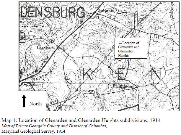
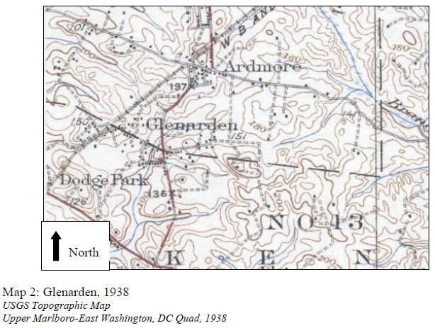
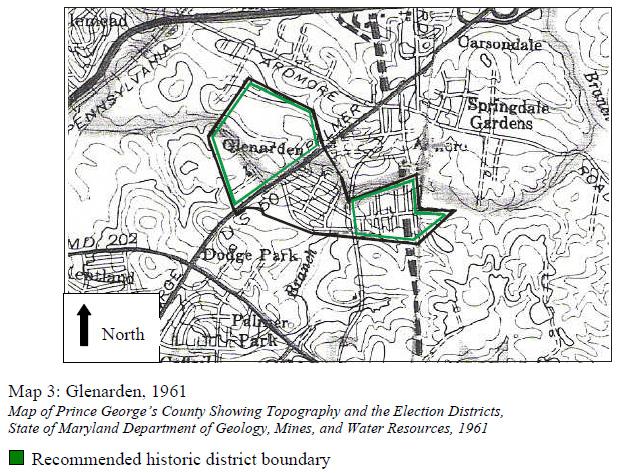
The development of Glenarden can be traced in a series of historic maps. The 1914 topographic map shows the route of the Washington, Baltimore and Annapolis Electric Railway, but the new subdivision is not named (Map 1). A map in the Prince George’s County Atlas published in 1938 shows the railroad line and a number of dwellings concentrated along Glenarden Parkway in Glenarden and Lincoln Avenue in Glenarden Heights, and a few in Ardwick Park near St. Joseph’s and on Piedmont Avenue (Map 2). The 1950 highway map shows the incorporated Town of Glenarden (with gravel-surfaced roads) bordered on the west by the George N. Palmer Highway, now located in the earlier railroad right-of-way. A 1961 Glenarden map shows the streets within the town boundaries 50 years after the community was originally platted (Map 3).
There are no designated historic sites or resources in Glenarden. Identified and documented properties include:
- 72-052, 8622 Johnson Avenue
- 72-055, 7941 Piedmont Avenue
- 72-056, Summer Acres, 334-416 Brightseat Road
- 72-057, Smith’s Barber Shop, 7907 Martin Luther King Jr. Highway
Works Cited
- Betty Bird and Associates, “African-American Resources in Prince George’s County, Maryland,” National Register of Historic Places, Multiple Property Documentation Form, October 2003
- Darsie, Julie, “Glenarden,” Maryland Historical Trust Maryland Inventory of Historic Properties Form, January 2001
- Deed Liber 59, Folio 298, Land Records of Prince George’s County, Maryland
- Deed Liber 60, Folio 398, Land Records of Prince George’s County, Maryland
- Denny, George D., “City of Glenarden,” in Proud Past, Promising Future: Cities and Towns in Prince George’s County, Maryland Brentwood, MD: George D. Denny Jr., 1997.
- General Highway Map, Prince George’s County, Maryland, 1950
- General Highway Map, Prince George’s County, Maryland, 1961
- “Glen Arden,”index card, Julius Rosenwald Fund Archives, Special Collections, John Hope and Aurelia Franklin Archives, Fisk University
- Harwood, Herbert H. Jr., “Washington, Baltimore and Annapolis Electric Railroad.” http://www.mdoe.org/wash_balt_annap_rr.html
- Pearl, Susan G., African-American Heritage Survey. Upper Marlboro, MD: Maryland National Capital Park and Planning Commission, 1996
- Pearl, Susan G., Glenarden: The Past in Perspective. Upper Marlboro, MD: Maryland- National Capital Park and Planning Commission, 1995
- Pearl, Susan G., “Railroads in Prince George’s County, 1835-1935,” Historic Contexts in Prince George’s County: Short Papers on Settlement Patterns, Transportation and Cultural History. Upper Marlboro, MD: Maryland-National Capital Park and Planning Commission, 1991
- Raymond Smith, personal interview, 4 August 2008
- Thornton, Alvin and Karen Williams Gooden, Like a Phoenix I’ll Rise: An Illustrated History of African-Americans in Prince George’s County Maryland. Virginia Beach, VA: The Dominion Publishing Company

Windshield Survey
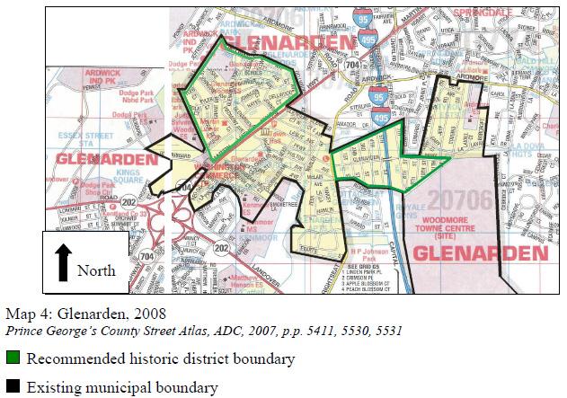
A windshield survey of Glenarden was conducted in June 2008 which counted approximately 1400 buildings in the Town. The suburban setting of the primarily residential community is largely unchanged from the previous survey, conducted in 1999. Glenarden is surrounded by wooded areas, providing a strong boundary for the community. House lots also feature many mature trees. The community is divided into three sections by two major north-south roads: Maryland Route 704, Martin Luther King Jr. Highway on the west, and I-495, the Capital Beltway, on the east (Map 4). A secondary north-south thoroughfare, Brightseat Road, lies between the two. The main west-east thoroughfare is Glenarden Parkway. The street pattern is composed of a grid system east of the King Highway section and curvilinear layout in the west. There are a number of cul-de-sacs, primarily in the western section. The major streets have sidewalks and curbs. The majority of houses in Glenarden have moderate setbacks and include driveways. (Streetscape photos 3, 4, 5, 10, 11, 14)
Few buildings from the first decade of development stand in the community. The earliest buildings are dwellings dating from the 1920s, and are either in the modest, vernacular with Colonial Revival characteristics (Photo 1) or bungalows (Photos 2, 6, 8, 9). Other residential building forms in the community include minimal traditional, Cape Cod (Photos 7, 12, 13), ranch, and split-level. The houses display a variety of cladding materials including brick, concrete block, and aluminum and vinyl siding, with some facades containing a mix of two materials. The houses east of Brightseat Road are larger than those on the west. Many of the smaller houses have been expanded with additions. A majority of the houses in the Town of Glenarden were constructed after the mid-1960s.
Glenarden Woods Elementary School is located in the northwestern section of the community, as is the Martin Luther King Jr. Community Center. The James R. Cousins Jr. Municipal Center and U.S. Post Office are located on the east side of Martin Luther King Jr. Highway in the center section of town. Nearby, in a park setting, is the Glenarden Community Center. The Glenarden Branch of the Prince George’s County Memorial Library is located on the east side of Brightseat Road at Glenarden Parkway, also in the center section of town. St. Joseph Catholic Church is located just east of the community boundary on Saint Joseph’s Drive in Largo. The few commercial buildings in the community are located on Martin Luther King Jr. Highway.
Today, the Town of Glenarden lacks the physical continuity of the original twentiethcentury subdivisions and a consistent sense of community. This is largely due to the incursion of two major north-south thoroughfares, the demolition of older housing stock in the 1960s and 1970s, expansion through annexation of adjacent subdivisions, and alterations to the original plan caused by modern construction projects. Glenarden does retain a strong physical boundary, with the borders marked by woods and few through streets spanning the city limits. There is a greater sense of community in the western section of the city, known as Glenarden Woods. In this area, no major roads cut through the site and the higher terrain screens the Martin Luther King Jr. Highway from the residential neighborhoods.
Historic District Evaluation
Glenarden represents three Prince George’s County Heritage Themes including “railroads”, “African-American history”, and “suburban growth.” Glenarden meets the following criteria for designation as a Prince George’s County Historic District: (1)(A)(i) and (1)(A)(iv) – Glenarden is significant as an early twentieth century suburban development established as a result of the creation of the Washington, Baltimore and Annapolis Electric Railroad in 1908. The community was marketed to African- Americans, and the first group of residents comprised both skilled and unskilled workers largely employed by either the federal government or the railroads. As a result of the efforts of the Glenarden Civic Association, Glenarden was incorporated in 1939 as the third African-American municipality in Prince George’s County.
The 2000 Maryland Inventory of Historic Properties form included an evaluation of the community’s eligibility for the National Register of Historic Properties as a Planned Suburban Neighborhood. While it was found that Glenarden possessed key characterdefining elements including a grid or curvilinear street pattern, consistent lot size and setbacks, and a cohesive grouping of buildings by function, the surveyor concluded that “the community does not contain a sufficient number of historic buildings to convey its association with suburbanization during the first half of the twentieth century.” surveyor recommended that the community be re-evaluated in ten years, when most of the buildings would meet the 50-year standard for consideration.30
While the purpose of the present document is not to evaluate Glenarden for National Register status, a National Register of Historic Places Multiple Property Documentation Form completed in 2003 can be useful in evaluating the community for Prince George’s County Historic District status.31 The documentation form makes the case that, because of the alteration and reuse of buildings due to segregation and the ability of buildings and structures to “document the dynamic of social and political change,” instead of strictly adhering to stands of architectural integrity in evaluating African-American resources, “integrity requirements should focus on aspects most closely linked with the associative and interpretive values of these resources.”32 Therefore, evaluating the integrity of Glenarden as a local historic district requires a judgment whether the town retains enough of the physical fabric from the historic period to communicate Prince George’s County historic themes.

In addition to the Town of Glenarden, the subdivisions of Glenarden Woods and Glenarden Heights may be eligible for designation as local historic districts according to Prince George’s County criteria (1)(A)(i) and (1)(A)(iv): Glenarden Heights and Glenarden Woods represent the continuum of progress and development in the county’s African-American communities from 1911 through the 1950s. Glenarden Heights spans the entire period and contains the original Glenarden Town Hall constructed in 1943 and small houses and cottages constructed in the 1920s through 1960s. In the northwestern part of Glenarden, Glenarden Woods is representative of the latter part of the historic period, when suburban development was fueled by the automobile. The community contains the Glenarden Wood Elementary School constructed in 1957 and modest dwellings constructed in the 1950s and 1960s. Alterations and additions to original dwellings do not detract from the communities’ historic character; Glenarden Woods and 30 Darsie, Ibid. 31 Betty Bird and Associates, “African-American Resources in Prince George’s County, Maryland,” National Register of Historic Places, Multiple Property Documentation Form, October 2003 32 Bird, Multiple Property Documentation Form, E-4 Glenarden Heights retain their historic location and association. The subdivisions of Glenarden Woods and Glenarden Heights possess a relatively moderate level of integrity (Map 4). The loss of setting is due to the alteration of the larger context of the Town of Glenarden during the urban renewal projects of the 1970s and 1980s.
- Susan G. Pearl, “Railroads in Prince George’s County, 1835-1935,” in Historic Contexts in Prince George’s County: Short Papers on Settlement Patterns, Transportation and Cultural History (Upper Marlboro, MD: Maryland-National Capital Park and Planning Commission, 1991), 46-47
- Deed Liber 59, Folio 298, Land Records of Prince George’s County, Maryland
- Deed Liber 60, Folio 398, Land Records of Prince George’s County, Maryland
- Susan G. Pearl, Glenarden: The Past in Perspective (Upper Marlboro, MD: Maryland-National Capital Park and Planning Commission, 1995), 3
- Ibid.
- Records of the Julius Rosenwald Fund identify the school built in Ardwick Park in 1922 as the “Glen Arden” school. Source: “Glen Arden,”index card, Julius Rosenwald Fund Archives, Special Collections, John Hope and Aurelia Franklin Archives, Fisk University
- Julie Darsie, “Glenarden,” Maryland Historical Trust Maryland Inventory of Historic Properties Form, January 2001
- Susan G. Pearl, Glenarden.
- Alvin Thornton and Karen Williams Gooden, Like a Phoenix I’ll Rise: An Illustrated History of African-Americans in Prince George’s County Maryland (Virginia Beach, VA: The Dominion Publishing Company), 93
- Susan G. Pearl, Glenarden.
- Susan G. Pearl, Glenarden.
- Herbert H. Harwood Jr., “Washington, Baltimore and Annapolis Electric Railroad.” Available on the World Wide Web at: http://www.mdoe.org/wash_balt_annap_rr.html
- George D. Denny, “City of Glenarden,” in Proud Past, Promising Future: Cities and Towns in Prince George’s County, Maryland (Brentwood, MD: George D. Denny Jr., 1997) 188
- General Highway Map, Prince George’s County, Maryland, 1950
- Denny, “City of Glenarden,” 187
- Ibid.
- Susan G. Pearl, African-American Heritage Survey (Upper Marlboro, MD: Maryland National Capital Park and Planning Commission, 1996) 84
- Raymond Smith, personal interview, 4 August 2008 19 Thornton, Like A Phoenix, 112
- Denny, 188
- Darsie, “Glenarden,” Maryland Inventory of Historic Properties Form
- General Highway Map, Prince George’s County, Maryland, 1961
- Darsie, Ibid.
- Ibid.
- Ibid.
- According to Raymond Smith, there was a small cemetery on the old church grounds. [Interview, Ibid.]
- Pearl, Glenarden, 10
- Darsie, Ibid.
- Pearl, Glenarden, 11


